
Figure:16-07-06-Rathaus Graz Turmblick-RR2 0275.jpg
Risoluzion plene (4 288 × 2 848 pixel, dimensions: 9,76 MB, gjenar MIME: image/jpeg)
Descrizion
| Descrizion |
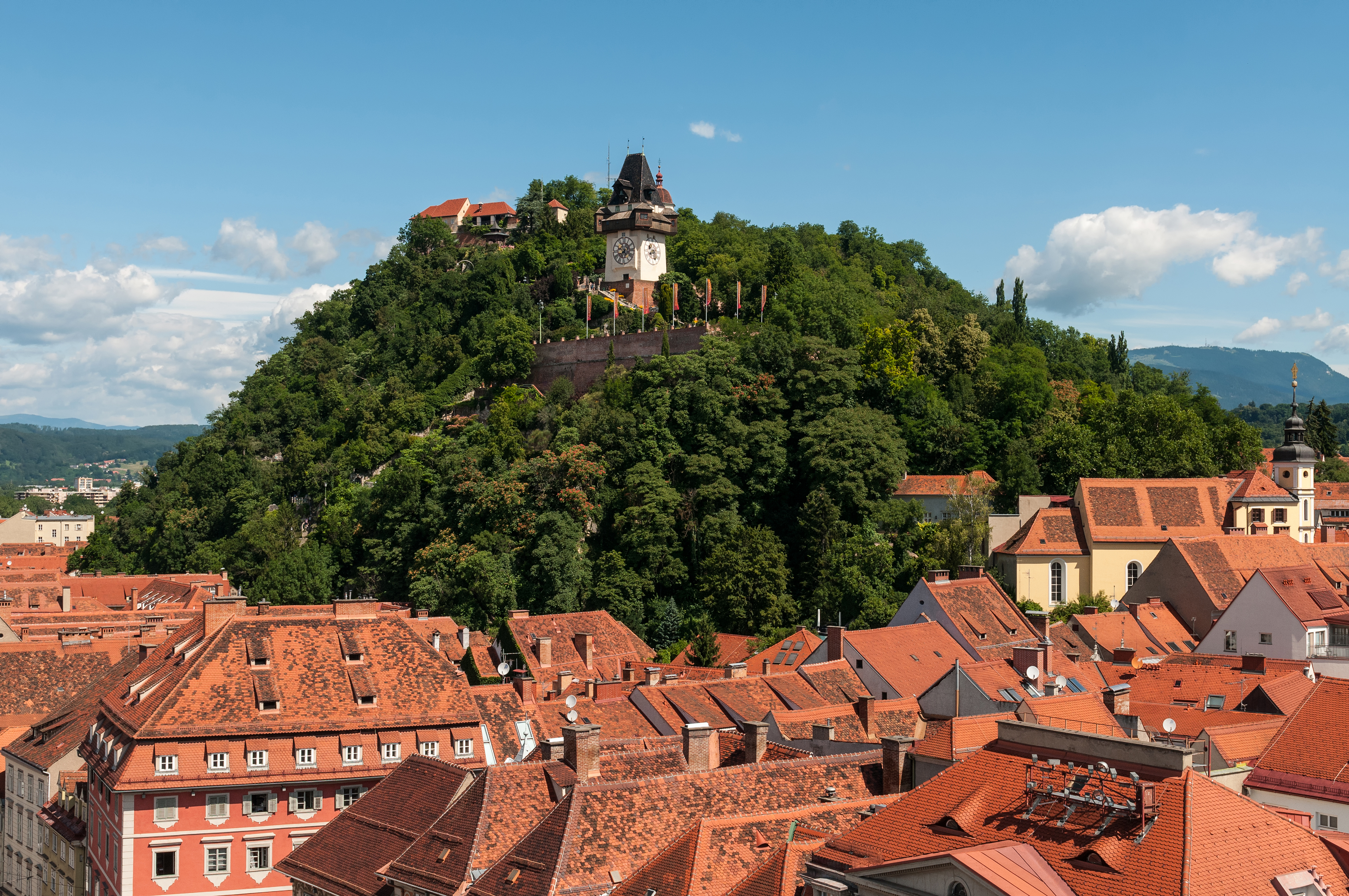
Deutsch: Schloßberg Graz, Blick von der Turmspitze des Rathauses
Čeština: Štýrský Hradec, pohled z věže radnice
Català: Castell del Pujol Graz, vista des de la torre de l'ajuntament
Español: Castillo de la Colina Graz, vista desde la torre del ayuntamiento
Русский: Шлоссберг Грац, Вид с башни ратуши
English: Castle mountain Graz, view from the spire of the town hall
|
|||||||||||||||||||||||
| Date | ||||||||||||||||||||||||
| Sorzint | Opere personâl | |||||||||||||||||||||||
| Autôr |
|
|||||||||||||||||||||||
| Permès (Torne a doprâ chest file) |
|
|||||||||||||||||||||||


| Luogo dello scatto | | Posizione di questa e altre immagini su: OpenStreetMap |
|---|
| Posizione del soggetto | | Posizione di questa e altre immagini su: OpenStreetMap |
|---|
Riconoscimenti
|
This image was selected as picture of the day on Wikimedia Commons for 6 July 2023. It was captioned as follows: English: Castle mountain Graz, view from the spire of the town hall. Other languages:
Čeština: Mohutná skála Schloßberg nad rakouským Štýrským Hradcem (Gratzem), z jehož radniční věže byl nafotografován tento snímek. Deutsch: Der Grazer Schloßberg. English: Castle mountain Graz, view from the spire of the town hall. Español: Schloßberg, vista desde la torre del ayuntamiento. Français : Le Schloßberg, colline de Graz (Autriche) abritant un jardin public et une forteresse. Vue ici depuis la tour de l'hôtel de ville. Italiano: Vista del monte castello di Graz dalla guglia del municipio, nella città di Graz in Austria. Nederlands: Blik op de Uhrturm op de Schlossberg in Graz, de hoofdstad van de Oostenrijkse deelstaat Stiermarken Português: Montanha do castelo em Graz, Áustria, vista da torre da prefeitura. |
Questa immagine è stata valutata utilizzando le linee guida sulla qualità delle immagini ed è considerata una immagine di qualità.
|
Wikipedia-Landtagsprojekt/Steiermark 20165. of July 2016 in Graz More than 10 persons participated in this project voluntarily and without expense allowance.
|
|
 |
Usage informationIf you need more information how to use this file, please send an |
|
The making of this work was supported by Wikimedia Austria. For other files made with the support of Wikimedia Austria, please see the category Supported by Wikimedia Österreich. |
The making of this document was supported by Skillshare.
To see other files made with the support of Skillshare, please see the category Supported by Skillshare. |
- Tu sês libar/libare
- di condividi – di copiâ, distribuî e trasmeti il lavôr
- di modificâ – di adatâ il lavôr
- A lis cundizions seguitivis
- Atribuzion – Tu âs di dâ lis informazions adeguadis sul autôr, un leam ae licence e dî se a son stâts cambiaments. Tu puedis fâ chest in cualsisei mût rasonevul, ma no in maniere di fâ pensâ che e avaledin te o la maniere che tu dopris la opare.
- condivît inte stesse maniere – Se tu modifichis, cambiis o tu amplis il materiâl, tu scugnis distribuî i tiei contribûts in base ae stesse licence o compatibil cul origjinâl.

Licence pal ûs

|
È permesso copiare, distribuire e/o modificare questo documento in base ai termini della licenza GNU Free Documentation License, solo versione 1.2, come pubblicata dalla Free Software Foundation; senza sezioni non modificabili, nessun testo copertina, e nessun testo di retro copertina. Una copia della licenza è inclusa nella sezione intitolata GNU Free Documentation License. | 1,2 solo |
Storic dal file
Frache suntune date/ore par viodi il file cemût che al jere in chel moment.
| Date/Ore | Miniature | Dimensions | Utent | Coment | |
|---|---|---|---|---|---|
| atuâl | 9 di Lui 2016 a lis 00:45 | | 4 288 × 2 848 (9,76 MB) | Ralf Roletschek | sky denoised |
| 8 di Lui 2016 a lis 22:26 |  | 4 288 × 2 848 (10,28 MB) | Ralf Roletschek |
Ûs dal file
No son vôs leadis a chest file.
ûs globâl dal file
Chestis altris vichis a doprin chest file:
- Ûs in am.wikipedia.org
- Ûs in an.wikipedia.org
- Ûs in ar.wikipedia.org
- Ûs in arz.wikipedia.org
- Ûs in ast.wikipedia.org
- Ûs in av.wikipedia.org
- Ûs in az.wikipedia.org
- Ûs in ban.wikipedia.org
- Ûs in ba.wikipedia.org
- Ûs in be-tarask.wikipedia.org
- Ûs in bg.wikipedia.org
- Ûs in bn.wikipedia.org
- Ûs in ca.wikipedia.org
- Ûs in ceb.wikipedia.org
- Ûs in ce.wikipedia.org
- Ûs in cs.wikipedia.org
- Ûs in cv.wikipedia.org
- Ûs in cy.wikipedia.org
- Ûs in de.wikipedia.org
- Österreich
- Belagerung von Graz
- Wikipedia:Landtagsprojekt/Steiermark/Locations
- Wikipedia Diskussion:Hauptseite/Artikel des Tages/Archiv/Vorschläge/2018/Q1
- Wikipedia:Hauptseite/Archiv/13. März 2018
- Portal:Österreich/RegiowikiAT Redundanzen
- Benutzerin:Alfonsina2019
- Liste der denkmalgeschützten Objekte in Graz/Innere Stadt/O–Z
- Wikipedia:WikiProjekt Österreich/checks/Denkmalschutz/WP - WD diffs 02
- Ûs in de.wikiversity.org
- Ûs in de.wikivoyage.org
- Ûs in de.wiktionary.org
- Ûs in el.wikipedia.org
- Ûs in en.wikipedia.org
- Ûs in en.wikivoyage.org
- Ûs in eo.wikipedia.org
- Ûs in eo.wikivoyage.org
- Ûs in eu.wikipedia.org
- Ûs in fa.wikipedia.org
- Ûs in fi.wikipedia.org
Mostrel'ûs globâl di chest file.