
Figure:Karte Aut Ooe BR.png
No son disponibilis versions cun risoluzion plui alte.
Karte_Aut_Ooe_BR.png (300 × 265 pixel, dimensions: 4 KB, gjenar MIME: image/png)
Descrizion
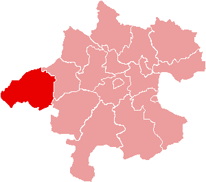
| Descrizion | Location of Bezirk Braunau am Inn within the Land of Upper Austria |
| Date | |
| Sorzint | de:Bild:Karte Aut Ooe BR.png |
| Autôr | de:Benutzer:Plp |
| Permès (Torne a doprâ chest file) |
GFDL-author (licence from German Wikipedia) |
| Altris versions | de:Bild:Karte Aut Ooe BR.png |
Licence pal ûs

|
Tu puedis copiâ, distribuî e/o modificâ chest document su la fonde de licence GNU Free Documentation License, Version 1.2 o seguitivis pubblicadis de Free Software Foundation; sence nissune sezion no modificabil, sence un testo di copertine e sence un test di quarte di copertine. Una copie de licence si ciate inte sezion intitulade Testo della GNU Free Documentation License. |
| Il file al à la licence di distribuzion di Creative Commons Attribution-Share Alike 3.0 Unported. | ||
| ||
| Questo tag di copyright è stato aggiunto nell'ambito dell'aggiornamento della licenza dei progetti Wikimedia. |
Storic dal file
Frache suntune date/ore par viodi il file cemût che al jere in chel moment.
| Date/Ore | Miniature | Dimensions | Utent | Coment | |
|---|---|---|---|---|---|
| atuâl | 23 di Jug 2006 a lis 16:58 | | 300 × 265 (4 KB) | Physchim62 | {{Information |Description=Location of Bezirk Braunau am Inn within the Land of Upper Austria |Source=de:Bild:Karte Aut Ooe BR.png |Date=2004 |Author=[[:de:Benutzer:Plp |Permis |
Ûs dal file
Lis vôs ca sot a son leadis a cheste figure:
ûs globâl dal file
Chestis altris vichis a doprin chest file:
- Ûs in ban.wikipedia.org
- Ûs in bs.wikipedia.org
- Ûs in cs.wikipedia.org
- Ûs in de.wikipedia.org
- Braunau am Inn
- Hochburg-Ach
- Höhnhart
- Maria Schmolln
- Altheim (Oberösterreich)
- Franking
- Haigermoos
- Mattighofen
- Mauerkirchen
- Mining
- Polling im Innkreis
- St. Johann am Walde
- Tarsdorf
- Treubach
- Überackern
- Weng im Innkreis
- Moosdorf
- Vorlage:Navigationsleiste Städte und Gemeinden im Bezirk Braunau am Inn
- Feldkirchen bei Mattighofen
- Schwand im Innkreis
- Aspach (Oberösterreich)
- Auerbach (Oberösterreich)
- Eggelsberg
- Gilgenberg am Weilhart
- Handenberg
- Helpfau-Uttendorf
- Jeging
- Kirchberg bei Mattighofen
- Lengau
- Lochen am See
- Moosbach (Oberösterreich)
- Munderfing
- Neukirchen an der Enknach
- Ostermiething
- Palting
- Perwang am Grabensee
- Pfaffstätt
- Pischelsdorf am Engelbach
- Roßbach (Oberösterreich)
- St. Georgen am Fillmannsbach
- St. Pantaleon (Oberösterreich)
- St. Peter am Hart
Mostrel'ûs globâl di chest file.