
Figure:Germany sorbian region.png
No son disponibilis versions cun risoluzion plui alte.
Germany_sorbian_region.png (188 × 235 pixel, dimensions: 3 KB, gjenar MIME: image/png)
Descrizion
| Descrizion |
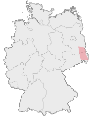
Deutsch: Karte von Deutschland mit den Grenzen der Bundesländer und dem ungefähren Verbreitungegebiet der Sorben rot markiert.
Hornjoserbsce: Korta z čerwjenje markěrowanym sydlenskim rumom Serbow.
English: Map of Germany with borders of its federal states and the red marked region where the Sorbs are living.
Español: En rojo la región aproximada donde viven los sorabos, superpuesta al mapa federal alemán. |
| Sorzint | Map drawn by User:Dabbelju on basis of Maps generated with http://www.opengeodb.de. |
| Autôr | User:Dabbelju |
| Permès (Torne a doprâ chest file) |
GFDL |
Licence pal ûs

|
Tu puedis copiâ, distribuî e/o modificâ chest document su la fonde de licence GNU Free Documentation License, Version 1.2 o seguitivis pubblicadis de Free Software Foundation; sence nissune sezion no modificabil, sence un testo di copertine e sence un test di quarte di copertine. Una copie de licence si ciate inte sezion intitulade Testo della GNU Free Documentation License. |
| Il file al à la licence di distribuzion di Creative Commons Attribution-Share Alike 3.0 Unported. | ||
| ||
| Questo tag di copyright è stato aggiunto nell'ambito dell'aggiornamento della licenza dei progetti Wikimedia. |
Storic dal file
Frache suntune date/ore par viodi il file cemût che al jere in chel moment.
| Date/Ore | Miniature | Dimensions | Utent | Coment | |
|---|---|---|---|---|---|
| atuâl | 29 di Avo 2007 a lis 22:10 | | 188 × 235 (3 KB) | 32X | updated by using Image:Karte Deutschland.png, added transparency |
| 15 di Nov 2005 a lis 23:16 |  | 188 × 235 (5 KB) | Dabbelju | ==Description== {{deutsch}} Karte von Deutschland mit den Grenzen der Bundesländer und dem rot markierten Lebensraum der Sorben. {{english}} Map of Germany with borders of its federal states and the red marked region where the [[:en:Sorbs |
Ûs dal file
Lis vôs ca sot a son leadis a cheste figure:
ûs globâl dal file
Chestis altris vichis a doprin chest file:
- Ûs in ar.wikipedia.org
- Ûs in ast.wikipedia.org
- Ûs in ba.wikipedia.org
- Ûs in be-tarask.wikipedia.org
- Ûs in br.wikipedia.org
- Ûs in bs.wikipedia.org
- Ûs in cs.wikipedia.org
- Ûs in cy.wikipedia.org
- Ûs in da.wikipedia.org
- Ûs in de.wikipedia.org
- Ûs in dsb.wikipedia.org
- Ûs in en.wikipedia.org
- Ûs in eo.wikipedia.org
- Ûs in et.wikipedia.org
- Ûs in fa.wikipedia.org
- Ûs in fr.wikipedia.org
- Ûs in fy.wikipedia.org
- Ûs in hr.wikipedia.org
- Ûs in hsb.wikipedia.org
- Ûs in hu.wikipedia.org
- Ûs in io.wikipedia.org
- Ûs in ja.wikipedia.org
- Ûs in lt.wikipedia.org
- Ûs in mn.wikipedia.org
- Ûs in oc.wikipedia.org
- Ûs in pl.wikipedia.org
- Ûs in ru.wikipedia.org
- Ûs in sv.wikipedia.org
- Ûs in uk.wikipedia.org
- Ûs in xmf.wikipedia.org